![]()
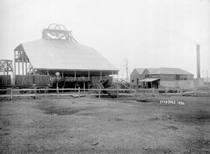
Mining Techniques in the 1800s
Below is an extract from the Royal Commission in 1886 where the commissioners chatted with the manager of Ferndale Colliery; 65. You have worked the coal under the Maitland Road, I believe? Yes. 66.. What depth is the coal from the surface under that road? It is about 1.5 feet from the surface down to the roof of the coal. 67. Of what rock is the roof composed ? Soft past. 68. And to the south -west of the Maitland Road, what is the depth of the coal ? It crops out just beyond the Maitland Road. 69. In that ...
Read More
Read More
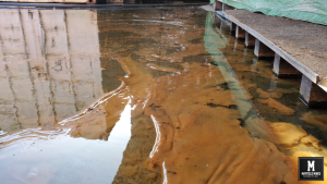
Mine Water from Abandoned Mine Workings
Permanently flowing from under Maitland Road Mayfield we have mine water coming from abandoned mine workings. Mine Subsidence Authority suggests the water is coming from old mine workings that were abandoned in the 1800s. Over the last years, the mine water in these abandoned mines has spread from one building, to now affecting all 3 buildings. It has also spread to our neighbours properties as well as Myola Street and Litchfield Park. abandoned mine water mine water 38 Maitland Road Mayfield warehouse mine water 38 Maitland Road Mayfield Carpark mine water 38 Maitland Road Mayfield Carpark mine water 38 Maitland ...
Read More
Read More
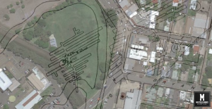
Mining Under Maitland Road Tighes Hill
From the Royal Commission; It appears that No.2 south headings were commenced with the ulterior intention of working out a considerable area of coal owned by the company south of Tighe’s Terrace street, and probably, also, of anticipating some of the small colliery owners referred to in working the coal from under the Maitland Road in the direction of the bridge across that creek. The colliery officials, on being interrogated on the point, affirmed that these bords, on reaching the western fence of the road, were stopped. Mr Inspector Dixon, however; suspected that these bords had crossed the ...
Read More
Read More
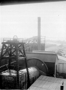
Bailers Needed to make Mine Workable before Accident
From the Royal Commission; A few months before the accident as many as twenty-one water-hailers were required to keep the working-places and roads in a comfortable and passable condition. Two special steam-pumps were placed at the bottom of the pumping-shaft that forced about 16,000 gallons of water per hour to the surface. These pumping-engines were supplied with steam from boilers on the surface. Ferndale Colliery Tighes Hill ...
Read More
Read More
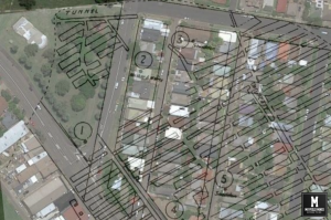
Full Hydraulic Connectivity – Mayfield Mines Permanently Flooded
From the Royal Commission; “To the south and east, and in close proximity to this shaft, three small collieries have worked the coal from under a number of building allotments, leaving no barriers. The workings to the west of these “headings” approached the Maitland Road, and a ‘spirited rivalry or competition seems to have existed among the conterminous small collieries as to which could work the greatest area of coal from under this important thoroughfare. No restrictions seem to have been imposed on the workers. In consequence, this road has been honeycombed with workings for a considerable distance, and is ...
Read More
Read More
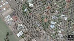
Royal Commission into Collieries 1886 Newcastle
Before we explain our current situation, its important to understand the historic legacy mines in our area. With the great help of the Royal Commission into Collieries document, I will be quoting word for word abstracts. Later, I will use current day reports and evidence to match with historical data. The Royal Royal Commission into Collieries 1886 was initiated because of the Lithgow Valley and Ferndale Colliery disasters and a near disaster at Maryville Colliery in 1886. With regards to Ferndale Colliery (the major colliery in the Tighes Hill region), on the 18th March 1886 a miner drowned and “water ...
Read More
Read More
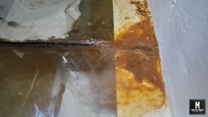
Mine Water Just Like the Zombie Shows
Have arrived to work today to find our very last workable area for our electronic workshop has mine water. We have moved our equipment so many times to find workable area and this was the last position. Absolutely shattered as we are unable to move the equipment anywhere else in the building. We might have been able to use a small space close to the Myola Street entrance but both Hunter Water and Newcastle Council continue to ignore stormwater flooding issues that have plagued us for more than 10 years – this results in stormwater coming in off the road ...
Read More
Read More
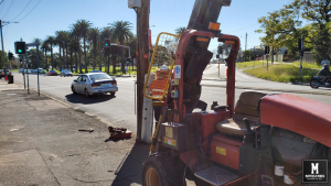
Mine Water Flow directly under Maitland Road Mayfield
Urgent stablization was required to secure the telegraph pole in front of our property at Maitland Road Mayfield NSW. Mine water is flowing directly underneath the road, under the footpath, and then directly into our lower warehouse permanently flooding us. Authorities have stated they believe its from old mine workings. Historic records confirm this – miners back in the 1880s were supposed to leave barriers of coal/soil between various mines, however, they failed to do so resulting in full connectivity of all the mines in the area. Also, mining was to have stopped before Maitland Road however records suggest that ...
Read More
Read More
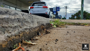
Maitland Road Mayfield Subsidence
Subsidence issues have been reported to all authorities including Newcastle Council, Mine Subsidence, NSW Government, local MPs and councillors for well over 12 years – maybe more than 100pc of evidence sent to authorities. Newcastle Council has written to us saying that the stormwater pipes are not causing our issues, but what has this got to do with stormwater issues? Other authorities have mentioned they are investigating (for years…) or they keep silent. Here are today’s photos of subsidence along Maitland Road Mayfield. Maitland Road Footpath Subsidence Maitland Road Subsidence ...
Read More
Read More
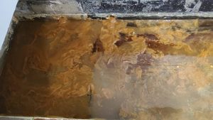
How to Destroy a Business – NSW Government & City of Newcastle Council NSW
It started as “seepage” in our warehouse in 2008, which then becomes 20,000,000 litres per year. This building is permanently flooded. Water then starts spreading onto our neighbouring properties where in 2019 water starts “seeping” into our office. After a little time, water was now running permanently through our office brick cavities, internal walls, through concrete slab and out of the wall facing Maitland Road. Now, this building is permanently flooded. “Seepage” has starting with our neighbours. You know how this finishes…… The NSW Government and City of Newcastle have completely ignored this problem. It is mine water that is ...
Read More
Read More