![]()
Not Mine Subsidence Related – it’s a Legacy Mines Problem according to SA NSW
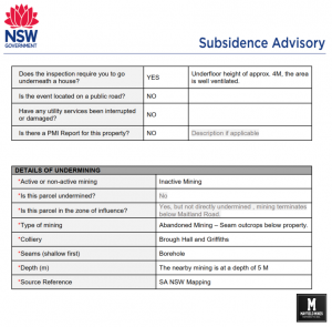
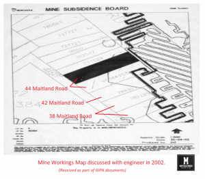
In Oct 2019, we called Subsidence Advisory NSW to visit our premises. They visit promptly and treat their inspection as a “Safety & Remediation Report” asking us to work with Legacy Mines department handing us the Legacy Mines brochure and contact number. Later, Subsidence Advisory NSW refused our claim suggesting; • There are no mines under 38 Maitland Road Mayfield • Mining terminates under Maitland Road • The nearest Colliery is Brough Hall and Griffiths • No damage to the building consistent with mine subsidence was observed or reported. Note: David Sedgman was the SA NSW representative who acknowledged mine ...
Read More
Read More
Subsidence Advisory NSW Acknowledge Mine Workings Privately
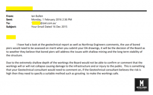
38 Maitland Road was abandoned by us in 2014 due to subsidence issues and flooding. We tried to get support from a variety of government agencies including Subsidence Advisory (Mine Subsidence Board), Newcastle City Council, Hunter Water, and more… All could not explain why the buildings were cracking and why we had water flowing into the buildings. In 2015, we try to sell 38 Maitland Road Mayfield, and allow a developer to handle their own investigation where they hired independent geotechnical engineers. These included RCA Australia, Northrop Engineers and Cardno (Stantec). As part of the analysis, the Cardno/RCA conducted lengthy ...
Read More
Read More
Subsidence Advisory NSW The Art of Doing Nothing (whilst looking like doing something)
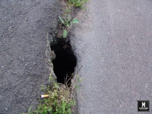
I believe corruption starts here all will be explained in upcoming posts. In 2012 and 2015, SA NSW visited our 38 and 42 Maitland Road Mayfield premises. During the visits, they suggested there were no mines under our buildings. Maitland Road had subsided and there was a sinkhole in the kerb (Newcastle City Council informed everyone that the hole was because of an old 1968 telegraph pole stump which was eaten by termites, creating the 3m wide crater), SA NSW suggested that the problems may be caused by old mine workings under Tarin Street. There is subsidence in opposite streets, ...
Read More
Read More
NSW Government Coverup
As more and more information is becoming available, its very evident that the NSW Government Coverup has been well in place for a number of years. After been told there were no mine workings beneath our properties for over 13 years, independent/government evidence on hand shows that the government has been aware of the mine network and has purposely withheld this information, in what we can only assume, to speed up as much financial losses that we bankrupt. Every building has honeycombing cracking and subsidence, every building has water damage due to mine water, 38 Maitland Road has been derelict ...
Read More
Read More
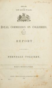
Mine Subsidence Maitland Road Mayfield (1884)
Mine Subsidence Maitland Road Mayfield (1884) Two years before the entire mine network was abandoned (in 1886), parts of Maitland Road were closed due to mine subsidence. Below is an extract from historical newspaper and government reports; Mr J McKenzie, inspector of the coalfields, has made a report by telegram and letter, to the Minister for Mines in reference to the undermining of the Maitland Road. “On arriving at Peppertown yesterday I found another pitfall had taken place on AA Co or southern side of Great Northern road caused by Spennymoor side taking away the coal adjacent to the road ...
Read More
Read More
Mines in Mayfield – Yes
Mines in Mayfield…yes. We still have people telling us that there was never mining in Mayfield. Whilst the mine network was dominated by Ferndale Colliery there was up to twenty smaller collieries mining in the Mayfield and Tighes Hill region. Below is a short extract from reports at the time. “….spirited rivalry or competition seems to have existed among the conterminous small collieries as to which could work the greatest area of coal from under this important thoroughfare. No restrictions seem to have been imposed on the workers. In consequence, this road has been honeycombed with workings for a considerable ...
Read More
Read More
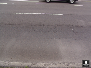
What has been happening over these last 12months with Mine Subsidence in Mayfield?
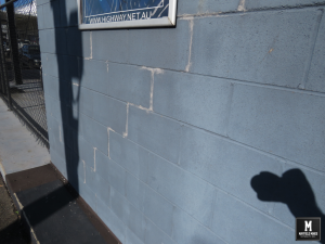
What has been happening over these last 12 months? More subsidence, more mine water flooding, but no action from government agencies. In these photos; – footpath subsidence in front of Thompson mechanics is now at ridiculous level – Litchfield Park has been flooded most months – Myola Street is peppered with potholes – new subsidence in all buildings – ongoing mine water with crazy humidity levels 44 Maitland Road Meeting Room 241029 38 Maitland Road 241029 – More Cracks Maitland Road Footpath Thompson Myola Street Potholes and Litchfield Partk Flooding ...
Read More
Read More
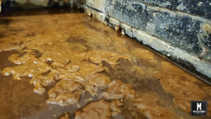
Subsidence Advisory NSW Withholding Information – Just the Facts
“Subsidence Advisory NSW is the NSW Government agency responsible for supporting property owners living in areas where subsidence from underground coal mining may occur.” Since our last posts 12 months ago, new information has emerged that Subsidence Authority NSW has purposely withheld information from us. Just the facts; In 1886, a network of mine workings were interconnected, flooded and abandoned in our region. This land was then sold to the public, with services built over the abandoned mine network. Over 15 years ago, water and subsidence damage started occurring in our property, later spreading to other properties. Subsidence Advisory informed ...
Read More
Read More
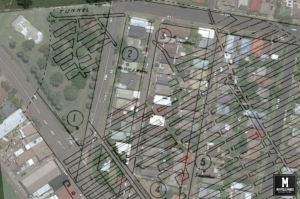
Legacy Mine Maps for Mayfield Have Been Received
After 15 months of lobbying the NSW government, we have finally received the geo-referenced abandoned “legacy” mine maps. We now have direct correlation between the location of the abandoned mine network with over 100 instances of subsidence damage in our properties. Water flowing “randomly” from under the footpath and into our properties (and others along the street) can be directly connected to the abandoned mines. In these 15 months, 25,000,000 litres have flowed through our properties. The water has permanently flooded Litchfield Park as well as other property owners. Subsidence and sink holes around Maitland Road now can be fully ...
Read More
Read More
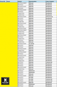
NSW Resource Regulator Approves Release of Abandon Mine Maps
After ongoing discussions with the NSW Resource Regulator, they reversed their decision in not releasing the map information to us, and after signing a 50 year non-disclosure agreement and paying $420, we received their abandoned mine map information. Sadly, information we had collected over these last years is more detailed that the documents received. It seems there are different government agencies not sharing documents in “one pool” of data. We are now waiting for news from Subsidence Advisory if they will release their geo-referenced maps of abandoned mines. Please Note; image is not 100% accurate, its information ...
Read More
Read More