![]()
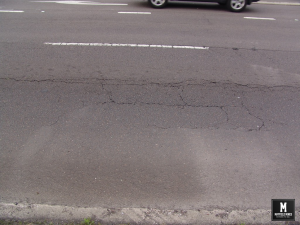
Mine Subsidence Maitland Road Mayfield (1884)
Mine Subsidence Maitland Road Mayfield (1884) Two years before the entire mine network was abandoned (in 1886), parts of Maitland Road were closed due to mine subsidence. Below is an extract from historical newspaper and government reports; Mr J McKenzie, inspector of the coalfields, has made a report by telegram and letter, to the Minister for Mines in reference to the undermining of the Maitland Road. “On arriving at Peppertown yesterday I found another pitfall had taken place on AA Co or southern side of Great Northern road caused by Spennymoor side taking away the coal adjacent to the road ...
Read More
Read More
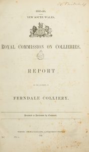
Mines in Mayfield – Yes
Mines in Mayfield…yes. We still have people telling us that there was never mining in Mayfield. Whilst the mine network was dominated by Ferndale Colliery there was up to twenty smaller collieries mining in the Mayfield and Tighes Hill region. Below is a short extract from reports at the time. “….spirited rivalry or competition seems to have existed among the conterminous small collieries as to which could work the greatest area of coal from under this important thoroughfare. No restrictions seem to have been imposed on the workers. In consequence, this road has been honeycombed with workings for a considerable ...
Read More
Read More
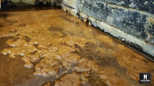
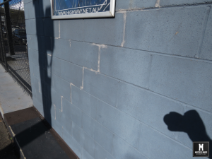
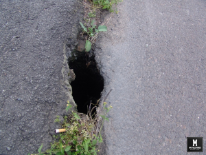
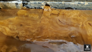
What has been happening over these last 12months with Mine Subsidence in Mayfield?
What has been happening over these last 12 months? More subsidence, more mine water flooding, but no action from government agencies. In these photos; – footpath subsidence in front of Thompson mechanics is now at ridiculous level – Litchfield Park has been flooded most months – Myola Street is peppered with potholes – new subsidence in all buildings – ongoing mine water with crazy humidity levels 44 Maitland Road Meeting Room 241029 38 Maitland Road 241029 – More Cracks Maitland Road Footpath Thompson Myola Street Potholes and Litchfield Partk Flooding ...
Read More
Read More
Subsidence Advisory NSW Withholding Information – Just the Facts
“Subsidence Advisory NSW is the NSW Government agency responsible for supporting property owners living in areas where subsidence from underground coal mining may occur.” Since our last posts 12 months ago, new information has emerged that Subsidence Authority NSW has purposely withheld information from us. Just the facts; In 1886, a network of mine workings were interconnected, flooded and abandoned in our region. This land was then sold to the public, with services built over the abandoned mine network. Over 15 years ago, water and subsidence damage started occurring in our property, later spreading to other properties. Subsidence Advisory informed ...
Read More
Read More
Legacy Mine Maps for Mayfield Have Been Received
After 15 months of lobbying the NSW government, we have finally received the geo-referenced abandoned “legacy” mine maps. We now have direct correlation between the location of the abandoned mine network with over 100 instances of subsidence damage in our properties. Water flowing “randomly” from under the footpath and into our properties (and others along the street) can be directly connected to the abandoned mines. In these 15 months, 25,000,000 litres have flowed through our properties. The water has permanently flooded Litchfield Park as well as other property owners. Subsidence and sink holes around Maitland Road now can be fully ...
Read More
Read More
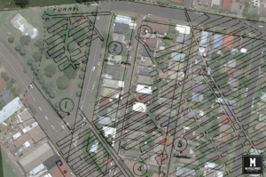
NSW Resource Regulator Approves Release of Abandon Mine Maps
After ongoing discussions with the NSW Resource Regulator, they reversed their decision in not releasing the map information to us, and after signing a 50 year non-disclosure agreement and paying $420, we received their abandoned mine map information. Sadly, information we had collected over these last years is more detailed that the documents received. It seems there are different government agencies not sharing documents in “one pool” of data. We are now waiting for news from Subsidence Advisory if they will release their geo-referenced maps of abandoned mines. Please Note; image is not 100% accurate, its information ...
Read More
Read More
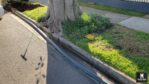
Broken Hunter Water Pipes on Ingall Street direct Correlation in Water Flows in Office
If you have been following our problem on mayfieldmines.com, you would understand that the abandoned mine network in Mayfield is full of water, and everytime extra water enters the network, it pushes the water out from mines under Maitland Road into our buildings. In 2020, a Legacy Mines NSW Report suggested broken Hunter Water pipes on Clara Street Mayfield were a significant factor in water flows into our buildings. During their 4 month investigation, Legacy Mines were taking regular water readings inside the abandoned mines. Legacy Mines drilled a bore on Clara Street as part of their investigation. During their ...
Read More
Read More
Legacy Mine Maps Appeal
We have appealed the decision from the NSW Resource Regulator and asked them to reconsider. Below are the reasons why they rejected to provide us the maps, together with our reply to Subsidence Advisory and the NSW Resource Regulator on why we should receive. • under section 121(6a) you must demonstrate that there is a legitimate concern about a risk to the health and safety of a person and that the provision of the survey plan available is likely to lessen that risk. You have not demonstrated how the provision of the plans are likely to lessen the risk to ...
Read More
Read More
Water is Flowing Harder in our Buildings
As we keep finding broken pipes along streets opposite us (here and here), water flows more strongly into our properties. Tonight, this is the water flow coming out of our meeting room wall in our office ...
Read More
Read More

Why are Old Legacy Mine Maps Kept from the Public?
Are old legacy mine maps kept from the public so that people do not fully understand they are in a mine subsidence district, or to minimise the amount of claims registered by home owners. During our discussions with home owners in our area, we found that many did not know that their properties were beneath a mine so they never fully understood why their wall was cracking or the garage subsiding. Then we also have owners who told us they applied for subsidence damage, only to be told they are not in the “zone of influence”. Lastly, we also have ...
Read More
Read More